Location and Size
The Eastern Region occupies a land area of 19,323 kilometres and constitutes 8.1 per cent of the total land area of Ghana. It is the sixth largest region in terms of land area. It lies between latitudes 6o and 7o North and between longitudes 1o30’ West and 0o30’ East. The region shares common boundaries with the Greater Accra and Central Regions to the south, to the north by Bono East Region, Ashanti Region to the west, the Volta Lake and Volta Region to the east.
Eastern Region is one of the sixteen administrative regions of Ghana with Koforidua as the administrative capital.
The Districts in the Colony that were located in the Eastern Region were the Akwapem-New Juaben and Birim which respectively had two and four native authorities. These Districts still belong to the Eastern Region of today but other areas have been added at different times after independence. There are 33 Municipalities and Districts in the region today.
Brief History
The Eastern Region was part of the British Colony, one of the three administrative areas of the then Gold Coast until independence. The other two administrative areas were Ashanti and Northern Territories. The administrative areas were divided into Districts and the Districts were also divided into native authorities. Native authorities during the colonial regime corresponded to what were known as states or traditional areas and were headed by paramount chiefs (Census Office 1962).
Akans are the dominant inhabitants and natives of Eastern region and Akan, Ewe, Krobo, Hausa and English are the main spoken languages. The Eastern region is the location of the Akosombo dam and the economy of the Eastern region is dominated by its high-capacity electricity generation.
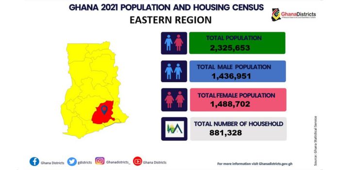
The population of the Eastern Region according to 2021 Population and Housing Census stands at 2,859,821 with 1,390,987 male and 1,468,834 female.


- Region Sublinks
- District Related
- Other Links
- Quick Links
- Saboba: Compensation 2022

 facebook
 X (twitter)
 Youtube
 +233 593 831 280
 0800 430 430
 GPS: GE-231-4383
 info@ghanadistricts.com
 Box GP1044, Accra, Ghana